Google Maps API を使ってみる
この Web ページで行うこと.
- Google Maps API を使って地図を表示してみる
- Google Maps API を使って地図上の緯度,経度を得る
準備
◆ JavaScript に関する Web ブラウザの設定
- Internet Explorer
インターネットオプションの「セキュリティの設定」で, 「スクリプト」→「アクティブ スクリプトを有効にする」
- Firefox
メニューのツール→オプション→Web 機能の設定
Google Maps API を使って地図を表示してみる
- センサー (sensor): false
- キャラクタセット (character set): Windows-31J
- ズーム: 12
- 緯度: 33.104053
- 経度: 131.78092
【関連する外部ページ】
- 「Google Map JavaScript API V3 チュートリアル」の Web ページ: https://developers.google.com/maps/documentation/javascript/tutorials
- https://developers.google.com/maps/documentation/javascript/streetview
<!DOCTYPE html public "-//W3C//DTD HTML 4.01 Transitional//EN" "https://www.w3.org/TR/html4/loose.dtd">
<html xmlns="http://www.w3.org/1999/xhtml" xml:lang="ja" lang="ja">
    <head>
        <meta http-equiv="Content-Type" content="text/html; initial-scale=1.0; charset=Windows-31J" />
        <meta http-equiv="Content-Style-Type" content="text/css" />
        <meta http-equiv="Content-Script-Type" content="text/javascript" />
        <meta http-equiv="MSThemeCompatible" CONTENT="yes" />

        <title>Google Maps API sample</title>

        <script type="text/javascript" src=//"maps.google.com/maps/api/js?sensor=false"></script>
        <script type="text/javascript">
        <!--
            google.maps.event.addDomListener(window, 'load', function() {
            var latlng = new google.maps.LatLng(33.104053, 131.78092);
            var myOptions = {
                zoom: 12,
                center: latlng,
                mapTypeId: google.maps.MapTypeId.ROADMAP,
                scaleControl: true,
            };
            var map = new google.maps.Map(document.getElementById("googlemap"), myOptions);
        });
        // -->
        </script>
    </head>

    <body style="width : 500px; height : 400px;">
        <div id="googlemap" style="width : 400px; height : 300px;"></div>
    </body>
</html>
- ROADMAP: 道路地図
- SATELLITE: Google Earth の航空写真
- HYBRID: Google Earth の航空写真と道路や地名との重ね合わせ
- TERRAIN: 地形
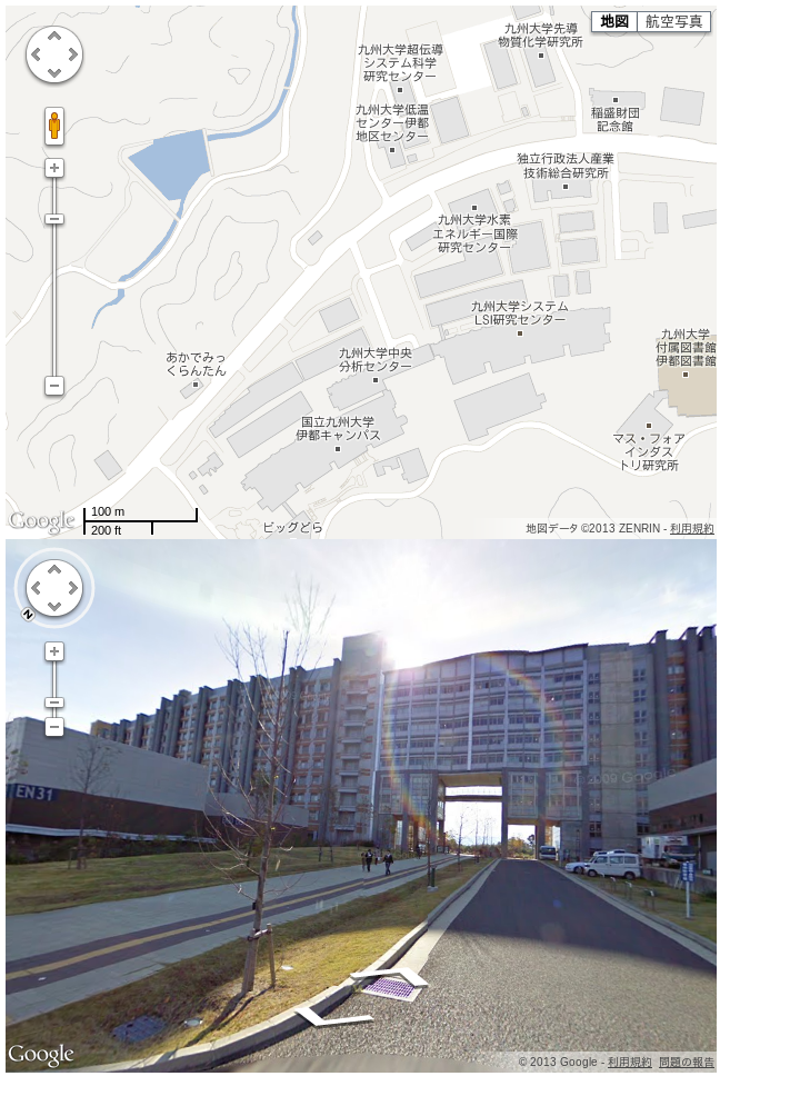
◆ Web ブラウザでの表示例
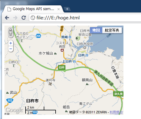 from
from 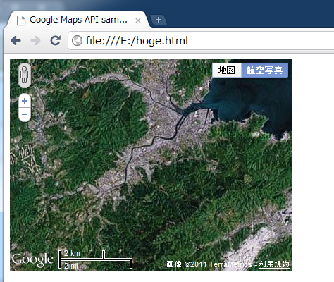 from
from 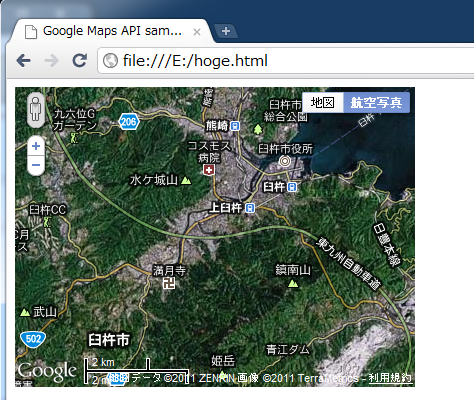 from
from 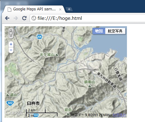 from
from ストリートビューの表示例
<!DOCTYPE html public "-//W3C//DTD HTML 4.01 Transitional//EN" "https://www.w3.org/TR/html4/loose.dtd">
<html xmlns="http://www.w3.org/1999/xhtml" xml:lang="ja" lang="ja">
    <head>
        <meta http-equiv="Content-Type" content="text/html; initial-scale=1.0; charset=Windows-31J" />
        <meta http-equiv="Content-Style-Type" content="text/css" />
        <meta http-equiv="Content-Script-Type" content="text/javascript" />
        <meta http-equiv="MSThemeCompatible" CONTENT="yes" />

        <title>Google Maps API sample</title>

        <script type="text/javascript" src=//"maps.google.com/maps/api/js?sensor=false"></script>
        <script type="text/javascript">
        <!--
            google.maps.event.addDomListener(window, 'load', function() {
            var latlng = new google.maps.LatLng(33.59656025053064, 130.21688103675842);
            var myOptions = {
                zoom: 17,
                center: latlng,
                mapTypeId: google.maps.MapTypeId.ROADMAP,
                scaleControl: true,
            };
            var map = new google.maps.Map(document.getElementById("googlemap"), myOptions);
            var panoOptions = {
                    position: latlng,
                pov: {
                heading: 135,
                pitch: 6
                                }
            };
            var panorama = new google.maps.StreetViewPanorama(document.getElementById("pano"), panoOptions);
                        map.setSteetView(panorama)
        });
        // -->
        </script>
    </head>

    <body style="width : 640px; height : 960px;">
        <div id="googlemap" style="width : 640px; height :480px;"></div>
        <div id="pano" style="width : 640px; height : 480px;"></div>
    </body>
</html>
 from
from Google Maps API を使って地図上の緯度,経度を得る
<!DOCTYPE html public "-//W3C//DTD HTML 4.01 Transitional//EN" "https://www.w3.org/TR/html4/loose.dtd">
<html xmlns="http://www.w3.org/1999/xhtml" xml:lang="ja" lang="ja">
    <head>
        <meta http-equiv="Content-Type" content="text/html; initial-scale=1.0; charset=Windows-31J" />
        <meta http-equiv="Content-Style-Type" content="text/css" />
        <meta http-equiv="Content-Script-Type" content="text/javascript" />
        <meta http-equiv="MSThemeCompatible" CONTENT="yes" />

        <title>Google Maps API sample</title>

        <script type="text/javascript" src=//"maps.google.com/maps/api/js?sensor=false"></script>
        <script type="text/javascript">
        <!--
        google.maps.event.addDomListener(window, 'load', function() {
        var latlng = new google.maps.LatLng(33.104053, 131.78092);
        var myOptions = {
            zoom: 12,
            center: latlng,
            mapTypeId: google.maps.MapTypeId.ROADMAP,
            scaleControl: true,
        };
        var map = new google.maps.Map(document.getElementById("googlemap"), myOptions);

          google.maps.event.addListener(
            map, 'click',
            function(e) {
                document.getElementById("latlng_disp").innerHTML = "(緯度, 経度)=(" + e.latLng.lat() + ", " + e.latLng.lng() + ")";
            });
        });

        // -->
        </script>
    </head>

<body style="width : 500px; height : 400px;">
    <div id="googlemap" style="width : 400px; height : 300px;"></div>

    <p>地図上をクリックすると、緯度・経度が地図の下に表示される.</p>
    <div id="latlng_disp"></div>
</body>
</html>
◆ Web ブラウザでの表示例
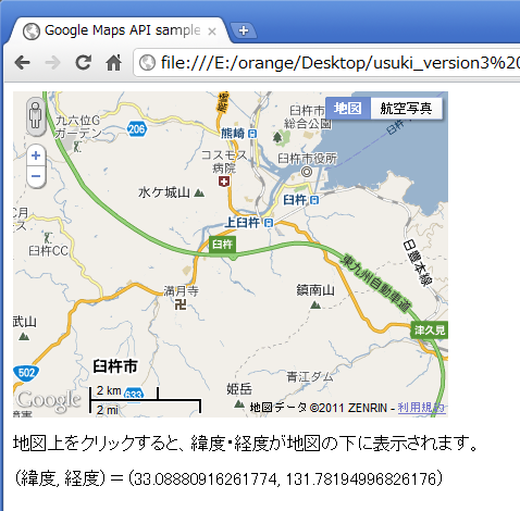 from
from プログラムの例
<!DOCTYPE html public "-//W3C//DTD HTML 4.01 Transitional//EN" "https://www.w3.org/TR/html4/loose.dtd">
<html xmlns="http://www.w3.org/1999/xhtml" xml:lang="ja" lang="ja">
    <head>
        <meta http-equiv="Content-Type" content="text/html; initial-scale=1.0; charset=Windows-31J" />
        <meta http-equiv="Content-Style-Type" content="text/css" />
        <meta http-equiv="Content-Script-Type" content="text/javascript" />
        <meta http-equiv="MSThemeCompatible" CONTENT="yes" />

        <title>Google Maps API sample</title>

        <script type="text/javascript" src=//"maps.google.com/maps/api/js?sensor=false"></script>
        <script type="text/javascript">
        <!--

        var marker_list=[];

        google.maps.event.addDomListener(window, 'load', function() {
        var latlng = new google.maps.LatLng(33.104053, 131.78092);
        var myOptions = {
            zoom: 12,
            center: latlng,
            mapTypeId: google.maps.MapTypeId.ROADMAP,
            scaleControl: true,
        };
        var map = new google.maps.Map(document.getElementById("googlemap"), myOptions);
          google.maps.event.addListener(
            map, 'click',
            function(e) {
                document.getElementById("latlng_disp").innerHTML = "(緯度, 経度)=(" + e.latLng.lat() + ", " + e.latLng.lng() + ")";
            });
        for (var i = 0; i < locations.length; i++) {
                var lpoint = locations[i];
                setMarkers(map, lpoint);
          marker_list[lpoint[0]]=setMarkers(map, lpoint);
          }

        });

        var txt01="<CENTER><IMG hspace=5 src='土づくりセンター.png' vspace=5 width=250 height=170><BR>土づくりセンター</CENTER>";
        var txt02="<CENTER><IMG hspace=5 src='野津町コープ.png' vspace=5 width=250 height=170><BR>野津町コープ</CENTER>";
        var locations = [
        ['土づくりセンター', 33.060184, 131.738541, txt01, 1],
        ['野津町コープ', 33.038123993773865, 131.6888639330864, txt02, 2]
        ];

        function setMarkers(map, lpoint) {
        var latlng = new google.maps.LatLng(lpoint[1], lpoint[2]);
        var marker1 = new google.maps.Marker({
            position: latlng,
            map: map,
            title: lpoint[0],
            zIndex: lpoint[4]
        });
        var infowindow = new google.maps.InfoWindow({
            content: lpoint[3]
        });
        google.maps.event.addListener(marker1, 'click', function(){
             infowindow.open(map,marker1);
        });
           return marker1;
        };

        function clickMarker(index){
        google.maps.event.trigger(marker_list[index], "click"); //click時に吹き出しを表示する
        }

        // -->
        </script>
    </head>

<body style="width : 1024px; height : 400px; bgcolor="#edf3ff">
  <table>
        <tbody>
        <tr>
            <td>
                <h1>臼杵市マップ</h1>
                <div id="googlemap" style="width: 800px; height: 600px;"></div>
                <br>
            </td>
            <td align="center">
                <a onclick="clickMarker('土づくりセンター');" href="javascript:void(0);">
                <img src="土づくりセンター.png" width="160" height="77">
                <br>
                土づくりセンター
                </a><br>
                <a onclick="clickMarker('野津町コープ');" href="javascript:void(0);">
                <img src="野津町コープ.png" width="160" height="120">
                <br>
                野津町コープ
                </a>
            </td>
        </tr>
        </tbody>
    </table>
    <p>地図上をクリックすると、緯度・経度が地図の下に表示される.</p>
    <div id="latlng_disp"></div>
  </body>
</html>
◆ Web ブラウザでの表示例
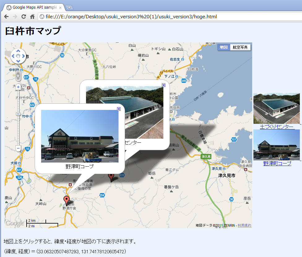 from
from