![[kaneko lab.]](https://www.kkaneko.jp/info/logo_png.png)
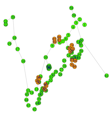
九州大学伊都キャンパス巡回バス地図
【概要】
九州大学の路線図から作成した地図の CSV データ(自作データ)を用い、Windows 上で SQLite3 にテーブルを定義して投入し、Python で辺の測地距離を計算してリレーショナルデータベースを作る手順を示す。
【目次】
【サイト内の関連情報】
前準備
Python 3.12 のインストール
Pythonのインストールを行い、Pythonのプログラムを実行する環境を整える。扱う環境は、Windows搭載パソコンである。金子研究室では、Python 3.12.10を推奨する。
[Windows での Python 3.12 のインストール手順を見るには、ここをクリック]
Windows での Python 3.12 のインストール
以下のいずれかの方法でPython 3.12をインストールする。Pythonがインストール済みの場合、この手順は不要である。
方法 1:winget によるインストール
【インストールコマンドの実行方法】
管理者権限でコマンドプロンプトを起動する(手順:Windowsキーまたはスタートメニュー → cmd と入力 → 右クリック → 「管理者として実行」)。そして、コマンド全体をコマンドプロンプトにコピー&ペーストする。
--scope machine を指定することで、システム全体(全ユーザー向け)にインストールされる。このオプションの実行には管理者権限が必要である。インストール完了後、コマンドプロンプトを再起動するとPATHが反映される。
REM Python 3.12 をシステム領域にインストール
winget install --id Python.Python.3.12 -e --scope machine --silent --accept-source-agreements --accept-package-agreements --override "/quiet InstallAllUsers=1 PrependPath=1 Include_test=0 Include_pip=1 Include_launcher=1 InstallLauncherAllUsers=1 TargetDir=\"C:\Program Files\Python312\""
if not "%ERRORLEVEL%"=="0" ( color 0c & echo Python 3.12 のインストールに失敗しました & ping 127.0.0.1 -n 6 >nul & color )

REM Python と Scripts を PATH 先頭に追加
powershell -NoProfile -Command "$p='C:\Program Files\Python312'; $s=\"$p\Scripts\"; if(Test-Path $p){$k=[Microsoft.Win32.Registry]::LocalMachine.OpenSubKey('SYSTEM\CurrentControlSet\Control\Session Manager\Environment',$true); $c=$k.GetValue('Path','',[Microsoft.Win32.RegistryValueOptions]::DoNotExpandEnvironmentNames); $t=$k.GetValueKind('Path'); $new=$c; if((';'+$new+';') -notlike \"*;$p;*\"){$new=$p+';'+$new}; if((';'+$new+';') -notlike \"*;$s;*\"){$new=$s+';'+$new}; if($new -ne $c){$k.SetValue('Path',$new,$t)}; $k.Close()}"

REM 現在のセッションにも反映(システムPATHを再取得して連結)
for /f "usebackq tokens=2,*" %A in (`reg query "HKLM\SYSTEM\CurrentControlSet\Control\Session Manager\Environment" /v Path`) do set "PATH=%B"

REM pip / wheel の更新
python -m pip install --no-user -U pip wheel
if not "%ERRORLEVEL%"=="0" ( color 0c & echo pip / wheel の更新に失敗しました & ping 127.0.0.1 -n 6 >nul & color )
方法 2:インストーラーによるインストール
- Python公式サイト(https://www.python.org/downloads/)にアクセスし、「Download Python 3.x.x」ボタンからWindows用インストーラーをダウンロードする。
- ダウンロードしたインストーラーを実行する。
- 初期画面の下部に表示される「Add python.exe to PATH」にチェックを入れてから「Customize installation」を選択する。このチェックを入れ忘れると、コマンドプロンプトから
pythonコマンドを実行できない。 - 「Install Python 3.xx for all users」にチェックを入れ、「Install」をクリックする。
インストールの確認
コマンドプロンプトで以下を実行する。
python --versionバージョン番号(例:Python 3.12.x)が表示されればインストール成功である。「'python' は、内部コマンドまたは外部コマンドとして認識されていません。」と表示される場合は、インストールが正常に完了していない。
Python の開発環境 Visual Studio Code のインストールと Python 用の設定
Python の開発環境Visual Studio Code(プログラムを編集するソフトウェア。以下、VS Code)を整える。
[Windows での Visual Studio Code のインストールと Python 用の設定手順を見るには、ここをクリック]
Windows での Visual Studio Code のインストールと Python 用の設定手順
1. VS Code と拡張機能のインストール
以下のコマンドにより,既存の VS Code を削除し,全ユーザー共有の設定で再インストールしたうえで,拡張機能(VS Code に機能を追加するソフトウェア)をまとめて導入する.
【インストールコマンドの実行方法】
管理者権限でコマンドプロンプトを起動する(手順:Windows キーまたはスタートメニュー → cmd と入力 → 右クリック → 「管理者として実行」)。そして,コマンド全体をコマンドプロンプトにコピー&ペーストする。
インストールコマンド
REM ============================================================
REM Microsoft Visual Studio Code
REM ============================================================
REM Build Tools + Desktop development with C++(VCTools)+ 追加コンポーネント(一括)
REM 未インストール時: winget で新規インストール
REM インストール済み時: setup.exe modify でコンポーネント追加(バージョンは変更しない)
winget list --id Microsoft.VisualStudio.BuildTools 2>nul | findstr /i "BuildTools" >nul 2>&1
if %ERRORLEVEL% EQU 0 (
    for /f "usebackq delims=" %P in (`"C:\Program Files (x86)\Microsoft Visual Studio\Installer\vswhere.exe" -products Microsoft.VisualStudio.Product.BuildTools -property installationPath`) do start /wait "" "C:\Program Files (x86)\Microsoft Visual Studio\Installer\setup.exe" modify --installPath "%P" --add Microsoft.VisualStudio.Workload.VCTools --add Microsoft.VisualStudio.Workload.MSBuildTools --add Microsoft.VisualStudio.Component.VC.CMake.Project --add Microsoft.VisualStudio.Component.VC.Llvm.Clang --add Microsoft.VisualStudio.Component.VC.Llvm.ClangToolset --add Microsoft.VisualStudio.Component.Windows11SDK.26100 --add Microsoft.VisualStudio.Component.VC.v143.x86.x64 --includeRecommended --quiet --norestart --nocache
    if not "%ERRORLEVEL%"=="0" ( color 0c & echo Build Tools のコンポーネント追加に失敗しました & ping 127.0.0.1 -n 6 >nul & color )
) else (
    winget install --scope machine --id Microsoft.VisualStudio.BuildTools -e --silent --disable-interactivity --force --accept-source-agreements --accept-package-agreements --override "--quiet --wait --norestart --nocache --add Microsoft.VisualStudio.Workload.VCTools --includeRecommended --add Microsoft.VisualStudio.Workload.MSBuildTools --add Microsoft.VisualStudio.Component.VC.CMake.Project --add Microsoft.VisualStudio.Component.VC.Llvm.Clang --add Microsoft.VisualStudio.Component.VC.Llvm.ClangToolset --add Microsoft.VisualStudio.Component.Windows11SDK.26100 --add Microsoft.VisualStudio.Component.VC.v143.x86.x64"
    if not "%ERRORLEVEL%"=="0" ( color 0c & echo Build Tools のインストールに失敗しました & ping 127.0.0.1 -n 6 >nul & color )
)

REM 全ユーザー共有の拡張機能フォルダ
if not exist "C:\ProgramData\vscode-extensions" mkdir "C:\ProgramData\vscode-extensions"
icacls "C:\ProgramData\vscode-extensions" /grant "Everyone:(OI)(CI)M" /T

REM スタートメニューのショートカットを --extensions-dir 付きで再作成
if exist "C:\ProgramData\Microsoft\Windows\Start Menu\Programs\Visual Studio Code" rmdir /s /q "C:\ProgramData\Microsoft\Windows\Start Menu\Programs\Visual Studio Code"
if exist "C:\ProgramData\Microsoft\Windows\Start Menu\Programs\Visual Studio Code.lnk" del "C:\ProgramData\Microsoft\Windows\Start Menu\Programs\Visual Studio Code.lnk"
powershell -NoProfile -Command "$s=New-Object -ComObject WScript.Shell; $lnk=$s.CreateShortcut('C:\ProgramData\Microsoft\Windows\Start Menu\Programs\Visual Studio Code.lnk'); $lnk.TargetPath='C:\Program Files\Microsoft VS Code\Code.exe'; $lnk.Arguments='--extensions-dir \"C:\ProgramData\vscode-extensions\"'; $lnk.Save()"
REM ショートカットの検証
powershell -NoProfile -Command "$s=New-Object -ComObject WScript.Shell; $lnk=$s.CreateShortcut('C:\ProgramData\Microsoft\Windows\Start Menu\Programs\Visual Studio Code.lnk'); Write-Host 'TargetPath:' $lnk.TargetPath; Write-Host 'Arguments:' $lnk.Arguments"

REM ファイル / フォルダ右クリックの「Code で開く」を登録
reg add "HKLM\SOFTWARE\Classes\*\shell\VSCode\command" /ve /d "\"C:\Program Files\Microsoft VS Code\Code.exe\" --extensions-dir \"C:\ProgramData\vscode-extensions\" \"%1\"" /f
reg add "HKLM\SOFTWARE\Classes\Directory\shell\VSCode\command" /ve /d "\"C:\Program Files\Microsoft VS Code\Code.exe\" --extensions-dir \"C:\ProgramData\vscode-extensions\" \"%1\"" /f
reg add "HKLM\SOFTWARE\Classes\Directory\Background\shell\VSCode\command" /ve /d "\"C:\Program Files\Microsoft VS Code\Code.exe\" --extensions-dir \"C:\ProgramData\vscode-extensions\" \"%V\"" /f

REM --extensions-dir 付きで起動する code.cmd ラッパを作成
REM (%* を echo で書くと対話的 cmd で失われるため、PowerShell で [char]37+'*' を書き出す)
powershell -NoProfile -Command "$pct=[char]37; $q=[char]34; $c='@echo off'+[char]13+[char]10+$q+'C:\Program Files\Microsoft VS Code\bin\code.cmd'+$q+' --extensions-dir '+$q+'C:\ProgramData\vscode-extensions'+$q+' '+$pct+'*'+[char]13+[char]10; [IO.File]::WriteAllText('C:\ProgramData\vscode-extensions\vscode.cmd',$c,[Text.Encoding]::ASCII)"

REM 拡張機能のインストール
set "CODE=C:\Program Files\Microsoft VS Code\bin\code.cmd"
"%CODE%" --extensions-dir "C:\ProgramData\vscode-extensions" --uninstall-extension GitHub.copilot
"%CODE%" --extensions-dir "C:\ProgramData\vscode-extensions" --uninstall-extension GitHub.copilot-chat
"%CODE%" --extensions-dir "C:\ProgramData\vscode-extensions" --install-extension ms-python.python
"%CODE%" --extensions-dir "C:\ProgramData\vscode-extensions" --install-extension ms-python.vscode-pylance
"%CODE%" --extensions-dir "C:\ProgramData\vscode-extensions" --install-extension ms-python.debugpy
"%CODE%" --extensions-dir "C:\ProgramData\vscode-extensions" --install-extension MS-CEINTL.vscode-language-pack-ja
"%CODE%" --extensions-dir "C:\ProgramData\vscode-extensions" --install-extension saoudrizwan.claude-dev
"%CODE%" --extensions-dir "C:\ProgramData\vscode-extensions" --install-extension rust-lang.rust-analyzer
"%CODE%" --extensions-dir "C:\ProgramData\vscode-extensions" --install-extension tamasfe.even-better-toml
"%CODE%" --extensions-dir "C:\ProgramData\vscode-extensions" --install-extension anthropic.claude-code
"%CODE%" --extensions-dir "C:\ProgramData\vscode-extensions" --install-extension almenon.arepl
"%CODE%" --extensions-dir "C:\ProgramData\vscode-extensions" --list-extensions --show-versions

REM settings.json を作成(自動更新オフ、Python、Claude Code 設定)
if not exist "%APPDATA%\Code\User" mkdir "%APPDATA%\Code\User"
python -c "import json,os;data={'update.mode':'none','update.enableWindowsBackgroundUpdates':False,'extensions.autoUpdate':False,'python.defaultInterpreterPath':r'C:\Program Files\Python312\python.exe','claudeCode.environmentVariables':[{'name':'ANTHROPIC_API_KEY','value':'not-needed'},{'name':'ANTHROPIC_AUTH_TOKEN','value':'ollama'},{'name':'ANTHROPIC_BASE_URL','value':'http://localhost:11434'},{'name':'ANTHROPIC_MODEL','value':'glm-4.7-flash'},{'name':'CLAUDE_CODE_DISABLE_NONESSENTIAL_TRAFFIC','value':'1'}]};p=os.path.join(os.environ['APPDATA'],'Code','User','settings.json');open(p,'w',encoding='utf-8').write(json.dumps(data,indent=4));print('Done:',p)"

REM 自動更新の抑止ポリシー(settings.json に加えて、レジストリ側でも明示的にオフ)
reg add "HKLM\SOFTWARE\Policies\Microsoft\VSCode" /v "UpdateMode" /t REG_SZ /d "none" /f
echo === セットアップ完了 ===
2. Python インタプリタの選択
同一マシンに複数の Python がインストールされている場合,VS Code で使用する Python 本体(インタプリタ:Python プログラムを解釈・実行するソフトウェア)を選択する必要がある.
- コマンドパレット(コマンド名で機能を呼び出す VS Code の入力欄)を開く(
Ctrl+Shift+P) Python: Select Interpreterと入力する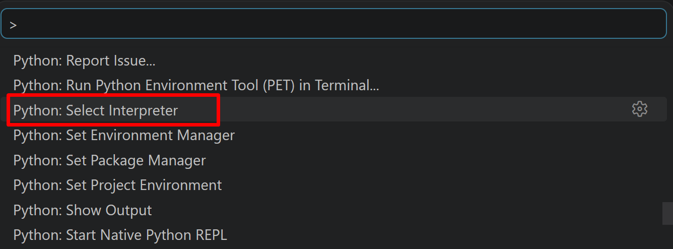
- 表示される一覧から,使用する Python(例:
C:\Program Files\Python312\python.exe)を選択する.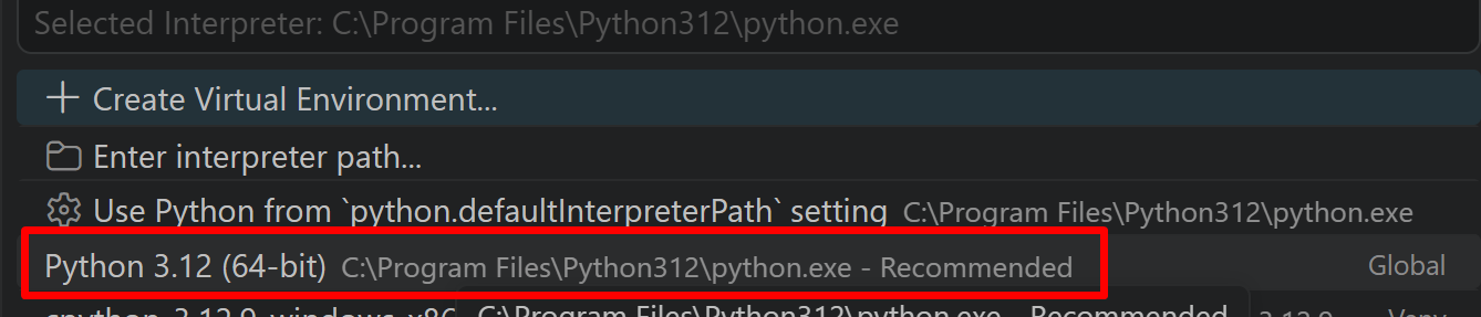
Python プログラム実行手順
[Windows での Python プログラム実行手順を見るには、ここをクリック]
Windows での Python 実行手順(Visual Studio Codeを使用)
プログラムファイルの作成と保存
- 左サイドバーの「エクスプローラー」アイコン(
Ctrl+Shift+E)をクリックする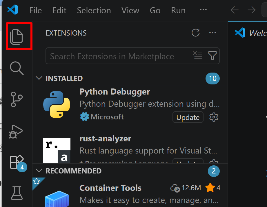
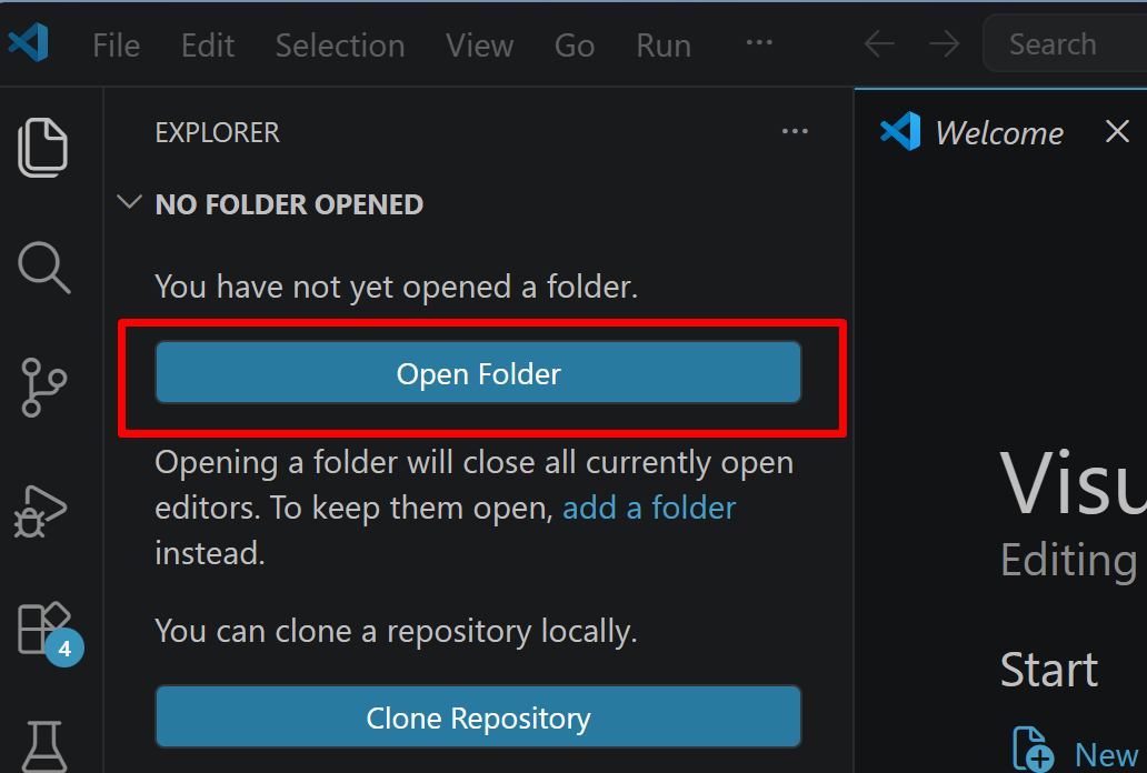
- 「NO FOLDER OPENED」(作業対象フォルダが未選択の状態)と表示される場合は,「Open Folder」をクリックし,プログラムを保存するフォルダを選択する
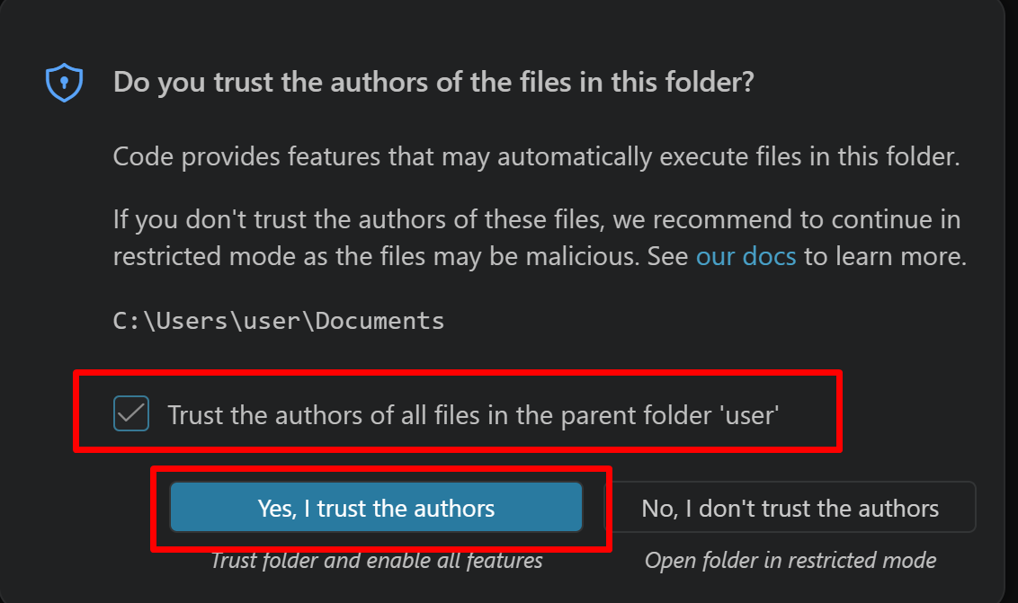
続いて「フォルダを信用するか」を確認する画面(フォルダ内のコードを実行してよいか確認する VS Code の仕組み)が表示されるので,チェックして Yes を選択する
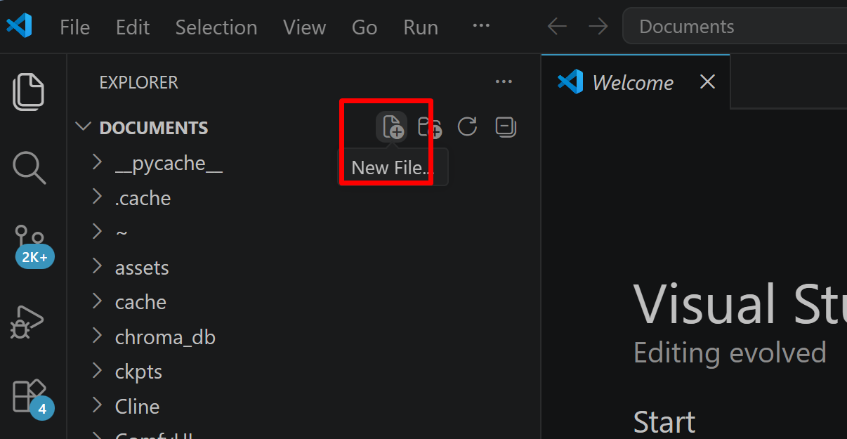
- フォルダ名の右側に表示される「新しいファイル」アイコンをクリックする
- ファイル名(例:
aitask.py.ファイル名は何でも良い)を入力しEnterを押す.拡張子は.py(Python ファイルを示す拡張子)とする
- 実行したいコードを選択し,
Ctrl+Cでコピーする.VS Code のエディタ領域にCtrl+Vで貼り付ける Ctrl+Sで保存する
プログラムの実行
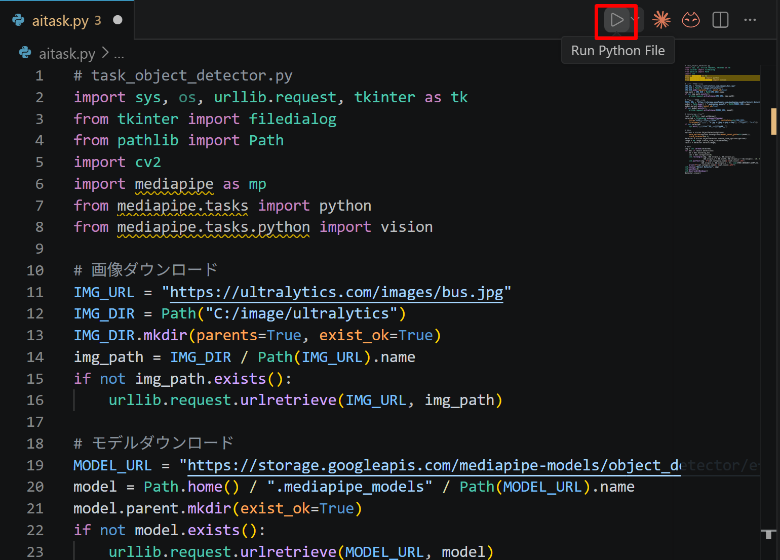
- エディタ右上の三角形「▷」アイコン(Run Python File:現在開いている Python ファイルを実行するボタン)をクリックする.または,エディタ上で右クリックし「ターミナルで Python ファイルを実行」を選択する
- VS Code 下部のターミナル(コマンドの入出力を表示する画面)に,実行結果(
print関数の出力等)が表示される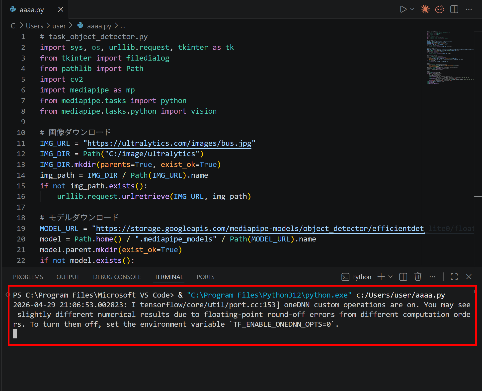
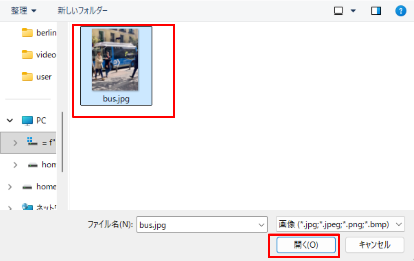
- tkinter(Python 標準の GUI ライブラリ)のファイル選択ダイアログを使うプログラムを実行した場合は,ダイアログが開くので対象画像を選択する
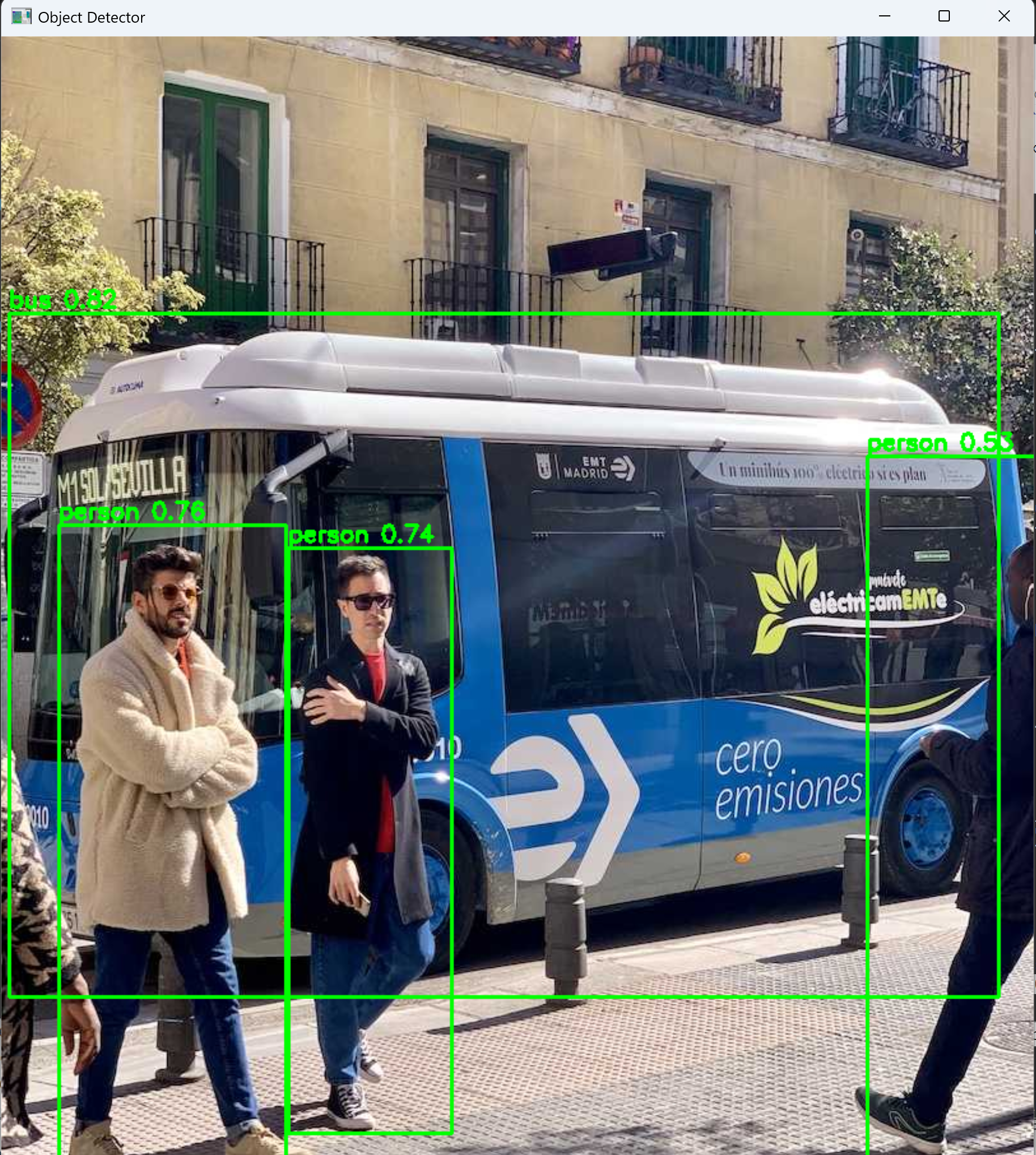
- VS Code 下部のターミナルで実行結果を確認する.OpenCV ウィンドウ(OpenCV が画像を表示するために開く専用ウィンドウ)が開いた場合はそちらも確認する.OpenCV ウィンドウは,マウスクリックでウィンドウをアクティブ(操作対象の状態)にしてからキーを押すと終了する

ライブラリのインストール
管理者権限でコマンドプロンプトを起動する(手順:Windows キーまたはスタートメニュー → cmd と入力 → 右クリック → 「管理者として実行」)
そして,以下のコマンドを実行。
pip install -U --no-user pandas matplotlib pyproj
あらかじめ決めておく事項
このページでは、データベースの作成を行う。作成するデータベースのデータベース名を決めておくこと。このページでは、次のように書く。
- データベース名: kyudaimapdb
データベース名は自由に決めてよいが、半角文字(英字と英記号)を使い、スペースを含まないこと。
CSV ファイル
ここで作成する CSV ファイルは次の3つである。
- nodes.csv : nodes データ (node_id, lat, lon, classification, feature, name)
- way_nodes.csv : way_nodes データ (way_id, seq, node_id)
- ways.csv : ways データ (way_id, classification, feature, name)
3つの CSV ファイルは、次の Python プログラムで生成する。
nodes_text = """node_id,lat,lon,classification,feature,name
1,33.59828875,130.2261751,highway,unclassified,""
2,33.59871117,130.2250575,highway,unclassified,""
3,33.59844209,130.2242221,highway,unclassified,""
4,33.59811244,130.2235519,highway,unclassified,""
5,33.59747289,130.2224231,highway,unclassified,""
6,33.59718842,130.2218779,highway,unclassified,""
7,33.59699096,130.2211885,highway,unclassified,""
8,33.59689391,130.2204669,highway,unclassified,""
9,33.59664291,130.2187673,highway,unclassified,""
10,33.59572591,130.217244,highway,unclassified,""
11,33.5942199,130.2160415,highway,unclassified,""
12,33.59378483,130.2157047,highway,unclassified,""
13,33.59321589,130.2151275,highway,unclassified,""
14,33.59294815,130.2140211,highway,unclassified,""
15,33.59311549,130.2132034,highway,unclassified,""
16,33.59542471,130.212081,highway,unclassified,""
17,33.59637517,130.2107822,highway,unclassified,""
18,33.59725535,130.2100607,highway,unclassified,""
19,33.5968002,130.2089062,highway,unclassified,""
20,33.5988852,130.2097079,highway,unclassified,""
21,33.59855923,130.2080243,highway,unclassified,""
22,33.59831793,130.2080564,highway,unclassified,""
23,33.59646553,130.222375,highway,unclassified,""
24,33.59588321,130.2225049,highway,unclassified,""
25,33.59546822,130.2214931,highway,unclassified,""
26,33.59503984,130.2215572,highway,unclassified,""
27,33.59475537,130.2208678,highway,unclassified,""
28,33.59438723,130.2205792,highway,unclassified,""
29,33.59458803,130.219569,highway,unclassified,""
30,33.59435376,130.2189276,highway,unclassified,""
31,33.59418643,130.2184947,highway,unclassified,""
32,33.59391869,130.2183825,highway,unclassified,""
33,33.59371789,130.2176128,highway,unclassified,""
34,33.59311549,130.2172761,highway,unclassified,""
35,33.59328282,130.2165064,highway,unclassified,""
36,33.59308202,130.216314,highway,unclassified,""
37,33.59284775,130.2162018,highway,unclassified,""
38,33.59278082,130.2159132,highway,unclassified,""
39,33.59244615,130.2157047,highway,unclassified,""
40,33.59214494,130.2156727,highway,unclassified,""
41,33.59211148,130.2153039,highway,unclassified,""
42,33.59164294,130.2146785,highway,unclassified,""
43,33.59194414,130.2132675,highway,unclassified,""
44,33.59237921,130.2128025,highway,unclassified,""
45,33.59281428,130.2129308,highway,unclassified,""
46,33.59565898,130.2233066,highway,unclassified,""
47,33.5956824,130.2242735,highway,unclassified,""
48,33.59569914,130.2248074,highway,unclassified,""
49,33.59595014,130.224979,highway,unclassified,""
50,33.59622792,130.2254135,highway,unclassified,""
51,33.59665964,130.2253702,highway,unclassified,""
52,33.59688052,130.2251505,highway,unclassified,""
53,33.59693742,130.2247272,highway,unclassified,""
54,33.5962982,130.2232569,highway,unclassified,""
55,33.59609739,130.223204,highway,unclassified,""
56,33.59576607,130.223871,highway,unclassified,""
57,33.59575938,130.2241976,highway,unclassified,""
58,33.59960808,130.2231446,highway,unclassified,""
59,33.59901906,130.2237187,highway,unclassified,""
60,33.59707128,130.2254664,highway,unclassified,""
61,33.59428683,130.231242,highway,unclassified,""
62,33.59499968,130.2178373,highway,unclassified,""
63,33.59506326,130.2180137,highway,unclassified,""
64,33.5949227,130.218158,highway,unclassified,""
65,33.5948223,130.2179495,highway,unclassified,""
66,33.5949227,130.2178854,highway,unclassified,""
67,33.59551507,130.2232874,building,university,""
68,33.59546822,130.2240179,building,university,""
69,33.59498964,130.2238774,building,university,""
70,33.59514693,130.2232425,building,university,""
71,33.59643876,130.2226877,building,university,""
72,33.59618106,130.222925,building,university,""
73,33.5963919,130.2234637,building,university,""
74,33.59668641,130.2232344,building,university,""
75,33.59388523,130.2152718,building,university,""
76,33.59415296,130.2155604,building,university,""
77,33.59405256,130.2157528,building,university,""
78,33.59375136,130.2154802,building,university,""
79,33.59328282,130.2168592,building,university,""
80,33.59361749,130.217212,building,university,""
81,33.59348362,130.2173563,building,university,""
82,33.59318242,130.2170837,building,university,""
83,33.59708467,130.2203547,building,university,""
84,33.5969508,130.2193124,building,university,""
85,33.59717503,130.2192323,building,university,""
86,33.59733567,130.2203386,building,university,""
"""

way_nodes_text = """way_id,seq,node_id
100,1,23
100,2,24
100,3,46
100,4,47
100,5,48
100,6,49
100,7,50
100,8,51
100,9,52
100,10,53
100,11,54
100,12,55
100,13,56
100,14,57
100,15,47
100,16,46
100,17,24
100,18,25
100,19,26
100,20,27
100,21,28
100,22,29
100,23,30
100,24,31
100,25,32
100,26,33
100,27,34
100,28,35
100,29,36
100,30,37
100,31,38
100,32,39
100,33,40
100,34,41
100,35,42
100,36,43
100,37,44
100,38,45
100,39,14
100,40,15
100,41,16
100,42,17
100,43,18
100,44,19
100,45,18
100,46,20
100,47,21
100,48,22
100,49,21
100,50,20
100,51,18
100,52,19
100,53,18
100,54,17
100,55,16
100,56,15
100,57,14
100,58,13
100,59,12
100,60,11
100,61,10
100,62,62
100,63,63
100,64,64
100,65,65
100,66,66
100,67,62
100,68,10
100,69,9
100,70,8
100,71,7
100,72,6
100,73,5
100,74,4
100,75,3
100,76,2
100,77,1
100,78,2
100,79,3
100,80,60
100,81,61
100,82,60
100,83,3
100,84,4
100,85,5
100,86,6
100,87,23
1,1,1
1,2,2
1,3,3
1,4,4
1,5,5
1,6,6
1,7,7
1,8,8
1,9,9
1,10,10
1,11,11
1,12,12
1,13,13
1,14,14
1,15,15
1,16,16
1,17,17
1,18,18
1,19,19
2,1,18
2,2,20
2,3,21
2,4,22
3,1,6
3,2,23
3,3,24
3,4,25
3,5,26
3,6,27
3,7,28
3,8,29
3,9,30
3,10,31
3,11,32
3,12,33
3,13,34
3,14,35
3,15,36
3,16,37
3,17,38
3,18,39
3,19,40
3,20,41
3,21,42
3,22,43
3,23,44
3,24,45
3,25,14
4,1,35
4,2,12
5,1,24
5,2,46
5,3,47
5,4,48
5,5,49
5,6,50
5,7,51
5,8,52
5,9,53
5,10,54
5,11,55
5,12,56
5,13,57
5,14,47
6,1,58
6,2,59
6,3,3
6,4,60
6,5,61
7,1,10
7,2,62
7,3,63
7,4,64
7,5,65
7,6,66
7,7,62
8,1,67
8,2,68
8,3,69
8,4,70
8,5,67
9,1,71
9,2,72
9,3,73
9,4,74
9,5,71
10,1,75
10,2,76
10,3,77
10,4,78
10,5,75
11,1,79
11,2,80
11,3,81
11,4,82
11,5,79
12,1,83
12,2,84
12,3,85
12,4,86
12,5,83
"""

ways_text = """way_id,classification,feature,name
1,highway,unclassified,""
2,highway,unclassified,""
3,highway,unclassified,""
4,highway,unclassified,""
5,highway,unclassified,""
6,highway,unclassified,""
7,highway,unclassified,""
8,building,university,""
9,building,university,""
10,building,university,""
11,building,university,""
12,building,university,""
100,route,bus,""
"""

with open("nodes.csv", "w", encoding="utf-8", newline="") as f:
    f.write(nodes_text)
with open("way_nodes.csv", "w", encoding="utf-8", newline="") as f:
    f.write(way_nodes_text)
with open("ways.csv", "w", encoding="utf-8", newline="") as f:
    f.write(ways_text)
CSV ファイルの表示
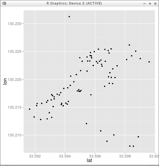
nodes データ (node_id, lat, lon, classification, feature, name) の緯度、経度を散布図で表示する。横軸を経度、縦軸を緯度とする。
import pandas as pd
import matplotlib.pyplot as plt

nodes = pd.read_csv("nodes.csv")
plt.scatter(nodes["lon"], nodes["lat"])
plt.show()
リレーショナルデータベースの生成
テーブル定義
- nodes(node_id, lat, lon, classification, feature, name, degree)
- way_nodes(way_id, seq, node_id)
- ways(way_id, classification, feature, name, is_open)
- edges(edge_id, node1, node2, gdist)
テーブルの定義、CSV ファイルの投入、way_nodes からの辺の生成、辺の測地距離 gdist の計算とテーブル edges への投入までを、1つの Python プログラムで行う。測地距離の計算には、WGS84 楕円体上の測地距離を計算する pyproj の Geod を用いる。
import sqlite3
import csv
from pyproj import Geod

dbname = "kyudaimapdb"
conn = sqlite3.connect(dbname)
cur = conn.cursor()

# テーブル定義
cur.execute("drop table if exists nodes")
cur.execute("""
create table nodes (
  node_id        integer  PRIMARY KEY autoincrement not null,
  lat            real  not null,
  lon            real  not null,
  classification text,
  feature        text,
  name           text,
  degree         integer
)
""")

cur.execute("drop table if exists way_nodes")
cur.execute("""
create table way_nodes (
  way_id         integer,
  seq            integer,
  node_id        integer
)
""")

cur.execute("drop table if exists ways")
cur.execute("""
create table ways (
  way_id         integer  PRIMARY KEY autoincrement not null,
  classification text,
  feature        text,
  name           text,
  is_open        integer
)
""")

cur.execute("drop table if exists edges")
cur.execute("""
create table edges (
  edge_id integer primary key autoincrement,
  node1 integer,
  node2 integer,
  gdist real
)
""")
conn.commit()

# nodes の投入
with open("nodes.csv", encoding="utf-8", newline="") as f:
    rows = list(csv.reader(f))[1:]
for node_id, lat, lon, classification, feature, name in rows:
    cur.execute(
        "insert into nodes(node_id, lat, lon, classification, feature, name) values (?,?,?,?,?,?)",
        (int(node_id), float(lat), float(lon), classification, feature, name)
    )
conn.commit()

# way_nodes の投入
with open("way_nodes.csv", encoding="utf-8", newline="") as f:
    rows = list(csv.reader(f))[1:]
cur.executemany("insert into way_nodes values (?,?,?)", [(int(a), int(b), int(c)) for a, b, c in rows])
conn.commit()

# ways の投入
with open("ways.csv", encoding="utf-8", newline="") as f:
    rows = list(csv.reader(f))[1:]
for way_id, classification, feature, name in rows:
    cur.execute(
        "insert into ways(way_id, classification, feature, name) values (?,?,?,?)",
        (int(way_id), classification, feature, name)
    )
conn.commit()

cur.execute("select * from nodes limit 10")
for row in cur.fetchall():
    print(row)
cur.execute("select * from way_nodes limit 10")
for row in cur.fetchall():
    print(row)
cur.execute("select * from ways limit 10")
for row in cur.fetchall():
    print(row)

# way_nodes の連続する2点から辺を生成する
cur.execute("""
insert into edges(node1, node2)
  select distinct A.node_id, B.node_id
  from way_nodes as A, way_nodes as B
  where A.way_id = B.way_id and A.seq = B.seq - 1
""")
conn.commit()

# 各辺の両端の緯度経度を取り出し、WGS84 楕円体上の測地距離を計算する
cur.execute("""
select edges.edge_id, A1.lon, A1.lat, A2.lon, A2.lat
from edges, nodes as A1, nodes as A2
where edges.node1 = A1.node_id and edges.node2 = A2.node_id
order by edges.edge_id
""")
latlon = cur.fetchall()

geod = Geod(ellps="WGS84")
edge_ids = [row[0] for row in latlon]
lon1 = [row[1] for row in latlon]
lat1 = [row[2] for row in latlon]
lon2 = [row[3] for row in latlon]
lat2 = [row[4] for row in latlon]
_, _, gdist = geod.inv(lon1, lat1, lon2, lat2)

cur.executemany("update edges set gdist = ? where edge_id = ?", zip(gdist, edge_ids))
conn.commit()

cur.execute("select * from edges limit 10")
for row in cur.fetchall():
    print(row)

conn.close()
テーブル edges には、次のような値が投入される(先頭部分)。
1,23,24,65.7038739521881
2,24,46,78.4599552184638
3,46,47,89.7854304998341
4,47,48,49.5914604960342
5,48,49,32.0740858824511
6,49,50,50.752137709759
7,50,51,48.0526457987608
8,51,52,31.8754630737111
9,52,53,39.7938630196082
10,53,54,153.789821334658
11,54,55,22.8076769154549
12,55,56,71.9958464175374
13,56,57,30.3241231498982
14,57,47,11.0695227972531
15,47,46,89.7854304998392
16,46,24,78.4599552183069
17,24,25,104.588490934714
18,25,26,47.8848850837779
19,26,27,71.3467155987657
20,27,28,48.8352869847077
21,28,29,96.3769355333057
22,29,30,64.9589981155187
23,30,31,44.2615670023388
24,31,32,31.4696778184444
25,32,33,74.8361655883246
26,33,34,73.7634654636914
27,34,35,73.8169756406262
28,35,36,28.5478314689245
29,36,37,27.9935517107653
30,37,38,27.798351376489
31,38,39,41.8623381840441
32,39,40,33.5405074956008
33,40,41,34.4340640522017
34,41,42,77.9150505007364
35,42,43,135.168632487512
36,43,44,64.743180324783
37,44,45,49.7036573617485
38,45,14,102.288535013693
39,14,15,78.1377835990947
40,15,16,276.505543623206
41,16,17,160.146353792369
42,17,18,118.387186308154
43,18,19,118.455212062789
44,19,18,118.455212062804
45,18,20,183.716967317859
46,20,21,160.394600235214
47,21,22,26.9291559303123
48,22,21,26.9291559299656
49,21,20,160.39460023525
50,20,18,183.716967317632
51,18,17,118.387186308147
52,17,16,160.146353792485
53,16,15,276.505543623021
54,15,14,78.1377835990385
55,14,13,106.906634826122
56,13,12,82.7806067381158
57,12,11,57.497518732198
58,11,10,200.899234039972
59,10,62,97.5757794427777
60,62,63,17.8276560874584
61,63,64,20.5537329306603
62,64,65,22.3283145006889
63,65,66,12.6256952683182
64,66,62,9.63509441488442
65,62,10,97.5757794427416
66,10,9,174.173755247864
67,9,8,160.192861889183
68,8,7,67.8375426417807
69,7,6,67.6334530134162
70,6,5,59.6351915898455
71,5,4,126.527621421435
72,4,3,72.1559441200289
73,3,2,83.0848001124146
74,2,1,113.822698357085
75,1,2,113.822698356889
76,2,3,83.0848001122443
77,3,60,190.934476780764
78,60,61,618.688581629668
79,61,60,618.688581629787
80,60,3,190.934476780898
81,3,4,72.1559441197823
82,4,5,126.527621421512
83,5,6,59.6351915900086
84,6,23,92.5076716304976
85,6,7,67.6334530134523
86,7,8,67.8375426418179
87,8,9,160.192861889168
88,9,10,174.173755247745
89,10,11,200.899234039749
90,11,12,57.4975187322279
91,12,13,82.780606738105
92,13,14,106.906634826058
93,35,12,92.9409705602022
94,58,59,84.3063027308876
95,59,3,79.2367316188885
96,67,68,68.0041169015511
97,68,69,54.6602913506111
98,69,70,61.4600033710786
99,70,67,41.0444233287955
100,71,72,36.08497814543
101,72,73,55.2002047225422
102,73,74,38.987533357354
103,74,71,57.701645414321
104,75,76,39.9928718068043
105,76,77,21.046353830033
106,77,78,41.9085447958451
107,78,75,24.3857517678189
108,79,80,49.5005952873161
109,80,81,19.9968953594562
110,81,82,41.9086426444658
111,82,79,23.6275240735169
112,83,84,97.8777877174605
113,84,85,25.9579981553192
114,85,86,104.21943380663
115,86,83,27.8797768797288